Today was supposed to be a fairly uneventful day for me, right up until I opened my wallet at the restaurant where I stopped for breakfast and found that one of my credit cards was missing! That sinking feeling (I'm sure you've all felt it) rendered my breakfast almost immediately undigestible. Thus began the thought process. Where did I use the card last? Should I dash right home and call to have it deactivated? How could I be so stupid? Fortunately, it didn't take me long to remember where I must have left it, and that place happened to be in Claremore. A call to them was like an early Christmas present for me because they assured me that indeed they had it and were taking good care of it for me! Whew! I told them I'd be there to fetch it in a couple of hours.
I'm never opposed to a ride on Route 66 at any time, so I wasn't at all bothered by the idea of this unexpected trip. After I picked up my wayward credit card and thanked them profusely, I decided to drive around a bit. Those of you who are slightly older will remember a singer named Patti Page. I vaguely remember my parents listening to her music, and I understand that she's still very much alive. Well, she was born in Claremore, and apparently Claremore is proud of that, because there is a road named after her. But, there's also a tiny strip mall named for her, and all that's in the mall are a loan company and a bail bond place. Just doesn't seem right, for someone of such stature. I'm just sayin. . .
 Also in Catoosa is an historic Route 66 bridge that was recently removed because it was deemed unsafe. There was much moaning and gnashing of teeth when this happened, but fortunately all of our unhappiness was assuaged when the wonderful Molly's Landing Restaurant, which sits right next to the former site of the bridge, took the entire huge thing and had it moved to their property! This has got to be one of the coolest things that ever happened on Route 66! The bridge now acts as part of the long driveway that leads up to the restaurant, thus it has not been lost to history.
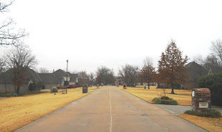
Just beyond Molly's Landing is a little-known section of old concrete Route 66 that winds through a most unexpected place, a rather upscale housing area. I always get a kick out of driving this section and attempting to imagine what it looked like when it wasn't lined with good sized houses and brick-encrusted mailboxes. Even the entrance to the housing development feels discordant, with an Historic Route 66 sign implanted in a brick pillar surrounded by little ionic columns.


5 comments:
Laurel,
That suburb with the old concrete section of 66, is that Spunky Creek?
Susan, I know that the suburb across Route 66 from the Whale is called Spunky Creek, but I don't think (although I'm not sure) that the one directly behind Molly's Landing is called that. It's not really part of the Spunky Creek neighborhood I'm familiar with. To get to the place I'm talking about, go down Molly's road but instead of making a right turn over the new (old) bridge, just keep going straight. The road ends at a dead end after passing the houses I described.
Lim once left her wallet at a Wal Mart. Thank God, someone found it and turned it in. All of her cards and such were still there. But, they took the cash as their reward. Oh well.
I was thinking of Spunky Creek neighborhood that's across 66 from Blue and so was picturing your exploration looking the wrong directions. I've heard Blaine Davis tell about the realignment of 66 and how that project was why/how Blue Whale's pond was dug. He said the old alignment ran along the opposite side of the Arrowood Trading Post and that what we see from 66 now is the back of the store. Spunky Creek is right there. I only had a vague idea where the older road was to the West of Blue, but now you've pinpointed it. I knew part of it ran by the Hard Rock, a continuation of 11th Street, but wasn't sure where it played out among all the new multi-lane roads when heading east.
Yes, Susan, that alignment that runs in front (back) of the Arrowood is definitely another old alignment of Route 66.
Post a Comment